


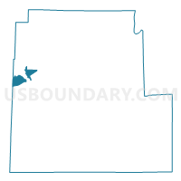
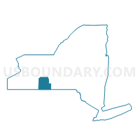
Voting District 190003, Steuben County, New York
About
Outline

Summary
| Unique Area Identifier | 636760 |
| Name | Voting District 190003 |
| County | Steuben County |
| State | New York |
| Area (square miles) | 8.78 |
| Land Area (square miles) | 8.78 |
| Water Area (square miles) | 0.00 |
| % of Land Area | 100.00 |
| % of Water Area | 0.00 |
| Latitude of the Internal Point | 42.33759000 |
| Longtitude of the Internal Point | -77.68850980 |
Maps

Graphs
Select a template below for downloading or customizing gragh for Voting District 190003, Steuben County, New York


Neighbors
Neighoring Voting District (by Name) Neighboring Voting District on the Map
- Voting District 040001, Allegany County, NY
- Voting District 140001, Steuben County, NY
- Voting District 180001, Steuben County, NY
- Voting District 180002, Steuben County, NY
- Voting District 180006, Steuben County, NY
- Voting District 180008, Steuben County, NY
- Voting District 190001, Steuben County, NY
- Voting District 190002, Steuben County, NY
Top 10 Neighboring County Subdivision (by Population) Neighboring County Subdivision on the Map
- Hornell city, Steuben County, NY (8,563)
- Hornellsville town, Steuben County, NY (4,151)
- Almond town, Allegany County, NY (1,633)
- Fremont town, Steuben County, NY (1,008)
Top 10 Neighboring Place (by Population) Neighboring Place on the Map
Top 10 Neighboring Unified School District (by Population) Neighboring Unified School District on the Map
- Hornell City School District, NY (10,765)
- Alfred-Almond Central School District, NY (7,414)
- Arkport Central School District, NY (3,097)
Top 10 Neighboring State Legislative District Lower Chamber (by Population) Neighboring State Legislative District Lower Chamber on the Map
Top 10 Neighboring State Legislative District Upper Chamber (by Population) Neighboring State Legislative District Upper Chamber on the Map
Top 10 Neighboring 111th Congressional District (by Population) Neighboring 111th Congressional District on the Map
Top 10 Neighboring Census Tract (by Population) Neighboring Census Tract on the Map
- Census Tract 9508, Allegany County, NY (6,384)
- Census Tract 9606, Steuben County, NY (4,152)
- Census Tract 9608, Steuben County, NY (3,048)
- Census Tract 9607, Steuben County, NY (2,953)
- Census Tract 9605, Steuben County, NY (2,850)
- Census Tract 9501, Allegany County, NY (2,555)